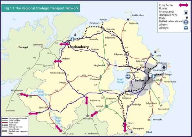
Regional Strategic Transport Network
An introduction to the Regional Strategic Transport Network, including key strategic transport corridors, link corridors and the road element.
Key strategic transport corridors and link corridors
The Regional Strategic Transport Network (RSTN) incorporates 5% of the road network, which carries around 37% of total vehicle travel, and all of the railway system. The map of Northern Ireland below highlights the RSTN.

Road element
The road element of the RSTN comprises:
- 5 Key Transport Corridors (KTCs)
- 4 Link Corridors
- the Belfast Metropolitan Transport Corridors
- the remainder of the trunk road network
The KTCs are the top tier of the Region's long distance routes connecting the cities and main towns to the major regional gateways and the Belfast Metropolitan Area (BMA) and they are:
- the Eastern Seaboard Corridor road and rail links between BMA and Dublin and northward to Larne; improving access to Warrenpoint and Rosslare. View the Eastern Seaboard Corridor and scheme brochure
- the North Western Corridor links the BMA to Londonderry, strengthening access to Belfast International Airport. View the North Western Corridor and scheme brochure
- the Northern Corridor links the M1 Moiria to Nutts Corner, Antrim, Ballymena, Ballymoney, Coleraine, Limavady and Londonderry by road and rail. View the Northern Corridor and scheme brochure
- the Western Corridor links west of Lough Neagh between Donegal, Londonderry, Strabane, Omagh, Monaghan and Dublin. View the Western Corridor and scheme brochure
- the South Western Corridor links the BMA to Craigavon, the Fermanagh Lakelands, the Sperrins and to important cross-border routes. View the South Western Corridor and scheme brochure